When developing housing and community development strategies, policy makers and urban planners rely on a deep understanding of the characteristics of the communities in which they work. While it can be simple to evaluate basic data points such as a community’s median income or the unemployment rate, it becomes challenging to characterize communities when comparing across multiple factors, such as educational attainment, population changes, levels of mortgage credit, or the nature of the underlying housing stock.
Recently, IHS worked with Chicago Metropolitan Agency for Planning (CMAP), Metropolitan Mayors Caucus (MMC), and Metropolitan Planning Council (MPC) to develop a housing market analysis to 1) identify the spatial patterns and characteristics of distinct subregional housing markets across northeastern Illinois and 2) identify a set of market-driven strategies responsive to local needs. The results of this collaborative effort were recently released through the Regional Housing Solutions website and our report detailing IHS's work developing the data and analysis is available for download at the bottom of this page.
About the Analysis
The foundation of the Regional Housing Solutions project is a housing market segmentation analysis of the seven county region surrounding Chicago, IL namely Cook, DuPage, Kane, Kendall, Lake, McHenry, and Will counties. IHS worked with faculty and students from DePaul’s Department of Predictive Analytics to develop a clustering algorithm to identify communities with similar characteristics regardless of physical proximity. The model incorporated over 40 census tract-level data points on the housing stock, housing affordability, housing market investment activity, and resident demographics and socioeconomic indicators that affect housing demand. For details on the data collected and a summary of the segmenation results, click here.
The goals of this analysis were to:
- Create a data-driven framework to facilitate regional discussions on housing challenges and opportunities
- Highlight how conditions vary spatially across the region
- Make connections between communities with similar underlying characteristics that may not have previously considered themselves peers
- Reveal the diversity of conditions within communities and towns so that planners can be responsive and targeted in their approach to the range of challenges present
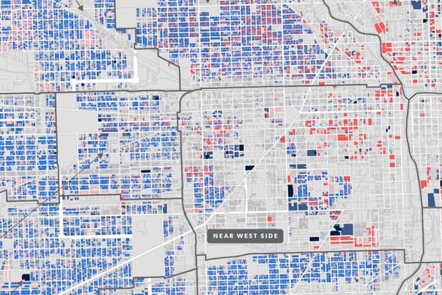
The map below illustrates the results of the segmentation model which identified eight distinct clusters in the Chicago seven county region. It clustered wealthy, economically distressed, and high-growth census tracts consistently and distinctly. Though the geographic location was not included as a variable, the results also highlighted a strong geographic pattern related to the historical evolution of urban development outward from downtown Chicago based on the age of the housing stock. It also identified a cluster unique in its high levels of growth, housing stock age, and income but geographically distinct, with tracts concentrated in downtown Chicago and dispersed in pockets across the region.
 Regional Housing Solutions Submarkets, Chicago Metro Area
Clusters were most strongly differentiated by age of housing, household income, population growth, and economic hardship indicators such as unemployment and foreclosure. The algorithm identified two low- to moderate-income primarily suburban clusters differentiated by housing stock, an aging population, and certain economic indicators. The algorithm also identified two high-wealth clusters: one typified by middle-aged homeowners in communities with moderate sales activities, and a second cluster of young, highly educated, urban professionals. Finally, two economically-distressed clusters were identified, differentiated by the varying degrees of unemployment, subsidized housing, and investment indicators.
This type of data modeling approach can be invaluable for urban planning, real estate development, geodemographic research, legislative policy work, economic investment, and more. To learn more about the Regional Housing Solutions collaboration, click here. For more detail on the data used in the report and IHS's Data Clearinghouse, click here.